Location
Overview#
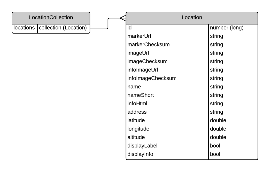
Data Model#
A location represents a physical location on Earth. It is identified by a name and address and can be located via a set of geo coordinates, latitude, longitude and altitude
Marker#
The marker is an image/icon that is displayed over the camera view and pinpoints the location. Each location can have a different marker image
-
markerUrl is a URL pointing to the image file on a remote server
-
markerChecksum allows the client app to download the image once and then only when the checksum changes, actually download the new version
Image#
The image is a thumbnail size picture displayed in the hover over label on the camera view. Each location can have a different image.
-
imageUrl is a URL pointing to the image file on a remote server
-
imageChecksum allows the client app to download the image once and then only when the checksum changes, actually download the new version
Info Image#
The infoImage is a larger size picture displayed in a information panel when the location is selected. Each location can have a different infoImage.
-
infoImageUrl is a URL pointing to the image file on a remote server
-
infoImageChecksum allows the client app to download the image once and then only when the checksum changes, actually download the new version
Name and Name Short#
Each location can have a long descriptive name and a shorter abbreviated name. The short name might be used in places where the screen real estate is minimal whereas the longer name can be used when more screen real estate is available.
Currently the CMS limits the short name to 100 characters and the longer name to 500 characters.
Info HTML#
The CMS allows any HTML mark up to be saved against a location. This provides the user with flexibility for styling content that is displayed about the location.
Address#
A simple string which represents the postal address of the location
Latitude, Longitude and Altitude#
These are the geo coordinates for pinpointing the location on a map
Display Label and Display Info#
The fields displayLabel and displayInfo are Boolean flags (true or false) which indicates if the client should display the label and info panels.
-
displayLabel is the hover over panel that shows the imageUrl and short name
-
displayInfo is the panel that shows information about the location (i.e. infoHtml)
List Locations#
This method will return all of the locations associated to a product (i.e. Channel)
| URL | /api/location/all/\<product id> |
|---|---|
| HTTP Method | GET |
| Request Headers | Content-Type: application/json; charset=utf-8 authentication-token: \<token> |
| Request Body Model | NA |
| Sample Request | NA |
| Response Model | LocationCollection |
| Sample Response | { “IsSuccess”: true, “Data”: { “locations”: [{ “id”: 3, “markerUrl”: null, “markerChecksum”: null, “imageUrl”: null, “imageChecksum”: “96190b42047ae6db73dc33d1718c221c”, “infoImageUrl”: null, “infoImageChecksum”: “244d4253a68f62cd83ed6c5f426e940f”, “name”: “Creating Realities”, “nameShort”: “Appearition”, “infoHtml”: “We are APPEARITION, a technology company that focuses on innovative and cutting edge solutions for bringing augmented reality into your world”, “address”: “352 Victoria Parade, East Melbourne VIC 3002”, “latitude”: -37.809425, “longitude”: 144.983276, “altitude”: 0.0, “displayLabel”: true, “displayInfo”: true }] }, “Errors”: [] } |
Managing content via the portal#
Please see (CreatingContentForLocationDemo.md) for further details